 |
||
LITTLE BLUFF JOURNAL - APRIL 2022 (previous months) |
|

Little Bluff cabin cam April 30 - TURN WHEN YOU SEE THIS SIGN - 10am-5pm today - HAPPY SATURDAY TO YOU!
OUR CANVAS GALLERY is open TODAY 04/30/22 or anytime by appointment (w/mask) - click for info

THIS weekend is the 21st anniversary of the epic SEARCH FOR HALEY story (much of it unfolded at our Cloudland Cabin). My ebook is available for only $9.99 on Amazon.
*Journal updated on the 17th - a new drainage and lots of waterfalls!
Print Of The Week special (above)
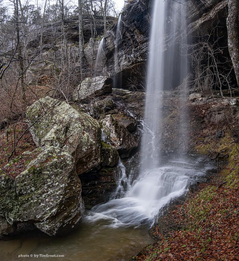
04/01/22 I made a quick run down into the top of Indian Creek Canyon early yesterday morning to photograph a very special 44' tall waterfall - EVANGELINE ARCHER FALLS (read about her at the park service web site here). My photo of it (below) is now available as one of the NEW 24"x36" limited-edition 50th anniversary prints of the Buffalo National River - click for more info.
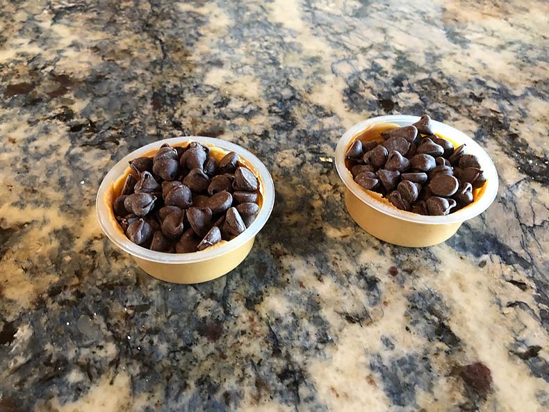
04/03/22 We sometimes get caught at the cabin without any desserts, but my lovely bride invented this yummy treat by pressing a pile of choc chips into these mini tubs of peanut butter - which is great when we're watching a long netflix series together, or as emergency ration for me when I'm out in the woods alone! Someone should come up with a commercial version of this, maybe all it "Reeses Peanut Butter Cups," haha! (we used to keep the original in the freezer when I was a kid and eat them frozen.)
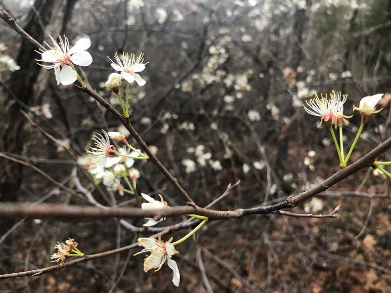
04/04/22 It took a while to reach the office this morning as I wandered through the forest following the heavy/heavenly aroma of the wild plum blossoms - such a delicate yet SWEET smell - almost as good as a chocolate-covered glazed donut!
Our friend Ranger Lauren posted a how-to video last week (here) about making your own small batch of redbud jelly (which we're going to try in the next week or two). I wonder if the flowers of these wild plums would be good?
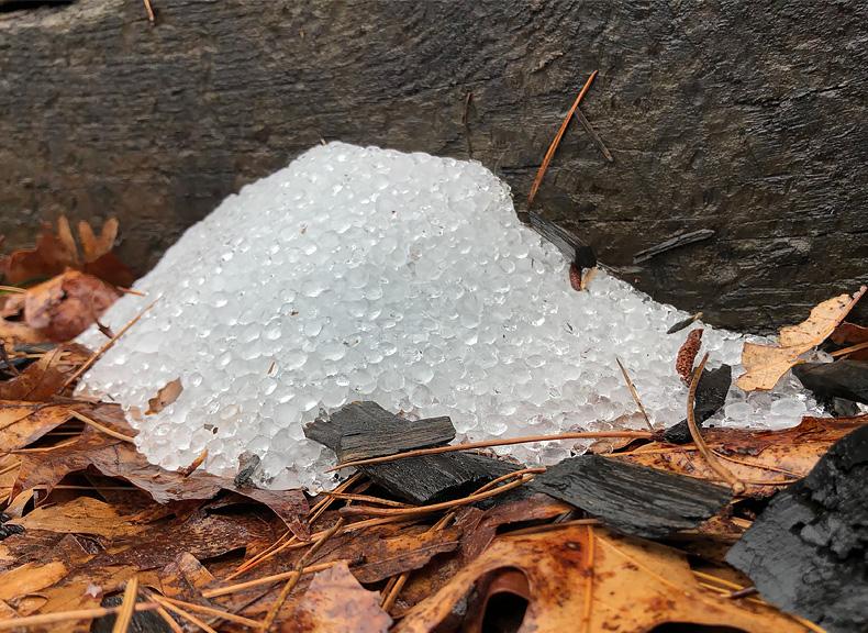
04/06/22 GOLFBALL-size hail pounded the cabin just after midnight but so far I've not seen any damage. It was LOUD! Late yesterday I made a quick trip into one of the most scenic (and rugged) wild areas in Arkansas waterfall photo (63'tall, above) - trip report later this week (I need to go back when there is more water). HAPPY WEDNESDAY TO YOU! (I'm headed into a more difficult spot this morning...)
04/08/22 We had a bit of heavy snow this morning - I had to keep my mouth shut while hiking to work because it was blowing so hard!
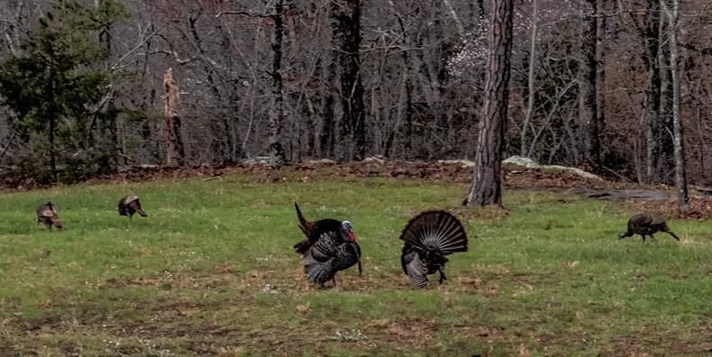
04/11/22 We had an amazing display of courtship from a pair of gobblers and there hens - they held us captive inside the cabin for 30 minutes - we did not dare leave for fear of scaring them off and missing the show!
04/12/22 Yesterday morning my lovely bride said there was a WHOPPER of a storm headed our way. We did get a little bit of hard rain and some wind, but nothing that tasted like it came from Burger King. After lunch I headed out with the pups to take the long trail back to work, down through the Boulder Jumble, past the big waterfalls, and along the creek. The forest was wet and almost silent. Then everything got dark, very dark. The wind picked up and the trees started thrashing around. And then off to our right came a FLASH, BOOM!!! It was the kind of lightning strike that shook the ground and I swear the earth rumbled. Twenty paces later another FLASH, BOOM!!! Only this one was much brighter and louder, and came from our left. My pace quickened but the pups didn’t seem to get the urgency of it all.
We decided to skip the office and kept going on the trail which eventually curved back towards the cabin. FLASH, BOOM!!!!!!! I saw the one hit over yonder down inside the Henson Creek canyon (that’s what we see from inside the cabin prow, the Henson Creek Drainage and Reynolds Mountain beyond). There was also a lot of rain, hard rain. We hiked on a little faster until reaching the cabin. While my bride was not happy about us being out in the storm, I actually enjoyed the heck out of it. I’ve almost always loved hiking in the rain.
As we sat in the prow watching the rest of the storm it began to hail - and soon there were piles of pea-size hail all over the place. Not nearly as LOUD as the lightning strikes, but the hail did produce a certain kind of music (music that one can only enjoy knowing all vehicles are under cover!).
Later in the afternoon I headed out the door again, this time to collect some redbud blossoms in hopes of making a batch of redbud jelly. (following Ranger Lauren's directions - here's her video) If successful it would be my very first batch of anything with jelly or jam in the name. Took me about 20 minutes to collect three cups of blossoms from several different trees in the nearby woods (step 1), though I probably could have just sat down and picked up ones that had been knocked to the ground by the hail - those didn’t seem to be as tasty though. Poured boiling water over them (step 2) and left to steep for 24 hours to make redbud tea (step 3) that would be the base of the jelly. Later today I’ll complete the project and see what happens! (steps 4-10, with #10 being “spread on toast!”).
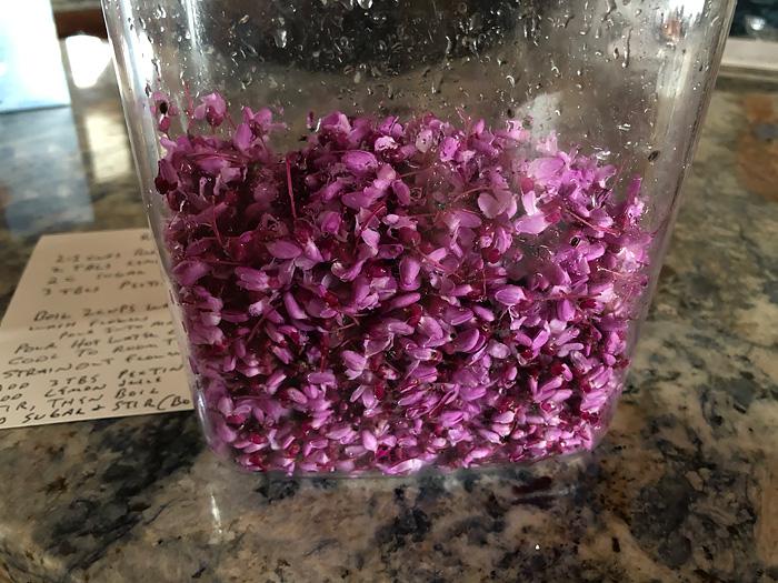

04/13/22 Got to taste redbud jelly for the first time this morning - I had not given it much hope of being any good - making jelly from small blooms on trees? YES, it was GREAT! Of course, I’m sure a lot has to do with all the sugar in the jar, but it was nice to make a flavor connection with those beautiful red (purple) buds that I’ve admired for so long.
Weather maps were looking good for a waterfall run somewhere today - supposed to have been wave after wave of fronts moving through that would top off our water table and maybe get some of the larger waterfalls running well. I had a plan (that doesn’t happen very often to me!). A couple of weeks ago while doing some historical research I found a photo by Neil Compton in his Buffalo River In Black and White book that peaked my attention. Though I’d had that book for several decades I never really paid attention to that particular photo before. Then I realized the photo was out of place in the book, showing the waterfall to be in the lower section of the Buffalo River. Yet it appeared to actually be in the upper section of the river in the headwaters of the Buffalo - or actually the headwaters of the Little Buffalo. Then I realized the waterfall has been in my Arkansas Nature Lovers guidebook forever - noted as a "W" on the map (waterfall), but no photo. I’d been to it many times but after searching through my files I never found my photo of it. Hum.
Last week I made a run over to Dismal Hollow to see if the waterfall in Neil’s book was indeed the same one in my guidebook - and it was. But there was little flow and I only made a couple of snapshots to confirm, hoping to return later. (my plan to document that trip here has not been done yet)
TODAY would be that day. Although by mid-morning we’d only received a small amount of rainfall and projected radar maps showed the rest of the waves during the day falling apart and/or going around where I needed them to be. By early afternoon I decided to make a run for Dismal Hollow and just take my chances. On the drive over there it looked like we’d had a lot more rain than the maps where showing, with even tiny streams running full tilt. Yet when I turned onto the crest of the Ozarks (Hwy. 16 that runs from Ozark to Deer), there didn’t seem like much water flowing at all - gosh darn it!
I’ve visited Dismal Hollow (Research Natural Area - thanks for the correct name Danny!) many times over the years and two things always happen to me - the first mile of bushwhacking (there are no trails) have been VERY tough do to so much of the forest being knocked down by the big ice storm of 2009, and also for some strange reason no matter how much time I allow myself I ALWAYS end up not having enough time to explore and take pictures, and always end up hiking out at the very last minute as darkness sets in.
Today I parked in a different location than normal and dropped down into a wide open gentle forest of big trees and mostly level terrain with no ice damage (how was that possible?). And while there didn’t appear to be any standing water (as would be normal if there had been a lot of rainfall that I needed), I almost immediately began to hear the roar of the river below - was I just hearing things?
Within 20 minutes of easy hiking I came to a crossing stream that feeds the main hollow, and it was flowing well, yea! Another few minutes and I was standing at the edge of the main scenic canyon and the creek and waterfalls were roaring - YIPPIE COYOTE!!! Game on.
I passed by a couple of waterfalls that I’d seen and photographed before and made my way down through a break in the big bluff line that runs through the area, then began to follow the bluff - just as the heavens above opened up and started pouring down on my head! Kind of funny - with the exception of a mistaken hike a couple of weeks ago when i forgot, I now wear my bike helmet whenever I’m bushwhacking like this - to help my hard head if I happen to slip and fall while all alone in the wilderness. That’s fine and I hardly even notice I’m wearing it any more, but today there were sheets of water pouring off that big bluff I was hiking below, and this helmet is not waterproof (in fact there are giant holes in the helmet for air circulation. Needless to say my entire body was soaked in just a minute or two.
This is one of the most beautiful bluff lines of the Little Buffalo River watershed, and the hike along the base is not too difficult. I passed one of the largest waterfalls (63’) and it was really THUNDERING! I’d photographed this one last summer running great as well, surrounded in GREEN. It was tough mentally to not stop again for photos, but I was on a mission today.
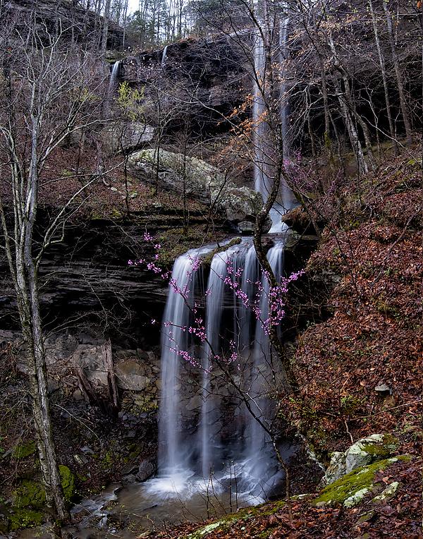
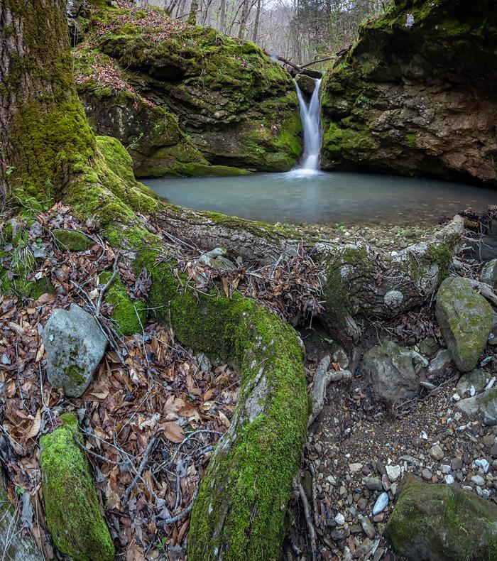
When I got closer to my target waterfall the rain had stopped and all I heard was silence. What? Did it’s micro drainage above not get any rainfall, and was this going to be another miss? My pace quickened. And then I came around a big corner of the bluff and the air was filled with waterfalls everywhere - the double-decker waterfall that had eluded me for so many years was - PERFECT - yippie COYOTE!
I spent the next hour taking pictures from on top of a giant boulder, which was about the only place I could shoot from since there was so much spray coming from the waterfalls (if you take off your lens cap to take a picture with spare in your face, the photos won’t work). When I visited last week I noted this spot as a perfect location to capture both of the waterfalls in the same frame. What I did not realize was that there would be a redbud tree right in the way! But oh well - it was IN BLOOM so I was an even happier camper!
My position on top of the very wet and slippery boulder was not very secure, and gravity was trying to send me off the top and down over the edge to certain doom below, so I had to be very careful of my footing and position of my body at all times. The perfect camera position required me to plant one foot solidly, then bend my body sideways with head bent over to be able to see through the viewfinder - easy to lose my balance. And I really needed to remove my bike helmet in order to get my eye close enough to the viewfinder - but bike helmets are very thick and this was a struggle. I thought over and over why not remove the helmet just for a few minutes - but NO, WAIT, DO NOT REMOVE HELMET! If I lost my balance that helmet might save my life.
Another issue that came up was my fingers quit working. I mean there was little blood in them and I had no feeling so it was difficult to operate the camera controls that I needed to - changing the exposure settings was a real pain (or actually no pain, I just could not control what I was doing!). So I ended up spending a lot of time redoing the settings that my numb fingers had set - and this with the temp more than 60 degrees.
In the end I did manage to get the photos I wanted, though there was one other problem. I could not stop taking pictures of these waterfalls! They were just so BEAUTIFUL! I did eventually manage to pack up and climb down off the rock. But I only made it about 50 feet before I stopped again at the base of the upper falls and spent another 30 minutes taking pictures from that vantage point. Again - couldn’t stop taking pictures, what’s the matter with me!?
There were more redbud trees in full bloom below the lower falls and I made my way around and down the other side but there was too many other trees in the way. Have you ever noticed how sometimes your eyes can zoom in on a blooming tree in the middle of the forest only to realize that when you try to take a picture of it there are all these other trees in the way?! So I turned around and headed back along the base of the big bluff, past rows of giant cinnamon ferns that were just coming up and in their “fiddlehead” phase (I’ve photographed them here before in all their glory).

On my way back I detoured down to and across the creek to the base of yet another thundering waterfall - one that is also shown as a “W” in the Nature Lover’s Guidebook but that I’d never photographed before (never enough time in this canyon!). The creek had already dropped below its previously flooded stage yet this waterfall continued to run well, so I set up and took a few pictures. It’s a waterfall that is SO tall (65’ plus a lot more above it that can’t be seen from the bottom) that I could not back up enough to get the entire falls in a single photo. It’s base is surrounded by a pile of large moss-covered boulders, and in fact I’m going to name it Mossy Boulders Jumble Falls (or something like that). Just beautiful.

As is almost always the case with me in this hollow, the sun began to fall and it was time to make a run to get back to the car before dark. But not before I visited four more waterfalls (three of them smaller, but still quite delightful) - no pics though. Quick trip back to the van and where a pickle pop awaited me - it was a great trip - thank you waterfall gods!
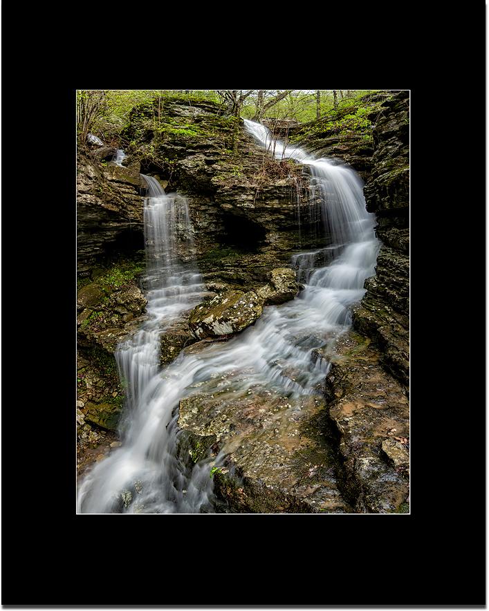
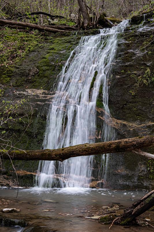
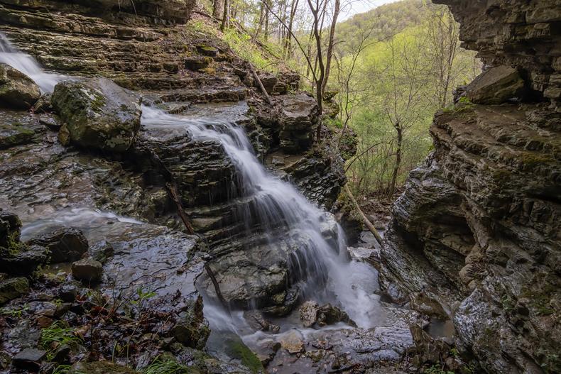
04/17/22 My plan today was to explore the upper part of a drainage I’d never set foot in, yet had skirted around dozens of times over the years via horse and hiking trails. Neither Neil Compton nor Ken Smith mention the drainage in any of their publications, and I’ve only seen one photo posted on social media (eight years ago). We had some nice rain the past couple of days so I was hoping to find a few new waterfalls. I knew it would be a tough hike - I knew it was VERY steep all around the headwaters, with lots of bluff lines throughout (close contours on the maps).
I had marked two spots on the map where I figured would be the best spots for waterfalls, so those were my main targets. But first I would have to get DOWN a few hundred vertical feet of unknown hillside. Since the distance was not going to be too far, I’d also planned to be back to the van for lunch, then drive to another area and explore for more new waterfalls. (haha)
With my bike helmet cinch up tight, and my big rubber boots on, I left the top of the ridge and headed DOWN into the unknown. Didn’t take me very long to realize the terrain was a LOT steeper in real life, and I was glad for the big lugs on my boots, and gloves - I’ve using gloves more and more on these bushwhack hikes since much of my travel is literally hand-over-fist going up (grabbing small trees or rocks for grip pulling up), or slip-and-slide in the loose leaves/dirt using small trees to help stabilize my control falling while going down.
Within ten minutes I had found the small creek and fought my way through thick brush to a spot where the world dropped away. There was a solid bluff below and the creek had eroded a path down through it. But up above me were twin steep cascades that seemed to be 75’ tall or even more - one was dry but the other was flowing a little bit. I was unable to take any sort of photo that would show how amazing this spot was, nor was I even able to measure the height. But I marked it on the map as an important point I needed to return to when the next big water event takes place! (though if that would be after the trees leafed out I might not be able to see much of it all from the ground.)
I was able to make my way down and around the bluff below, carefully working back around to the creek - with good water this spot would be really nice with a small waterfall but a good view of the bottom where the twin cascades came together - though if the water was high I may not be able to even get a photo due to waterfall spray - and I’l probably need a safety rope. It was a good start to my trip, yea!
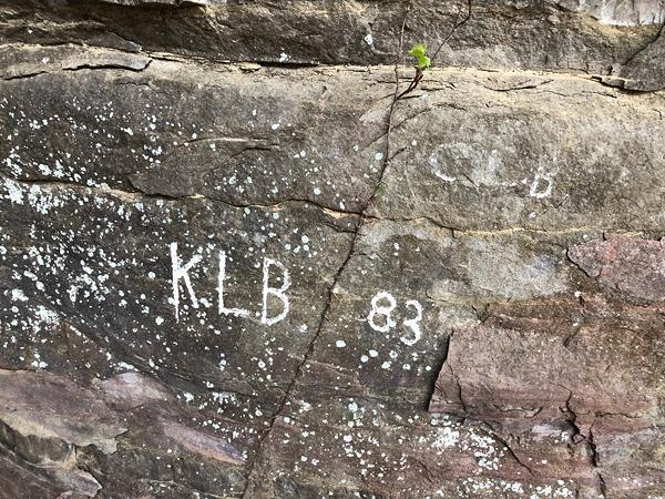
Heading on down the creekbed I passed a small waterfall underneath a shelter bluff (along with some ancient graffiti - I wonder at one point that would become “historical”?), and then a nice waterfall on the main creek - running OK for a photo even though it was obvious clear the creek was not flowing all that much. Before long I found another waterfall on the main creek, and stopped to take pictures.
The creekbed leveled out and got really slick - limestone that had been worn down by eons of creek erosion, yet the forest on both sides of the creek were home to a healthy population of really bad sticker bushes (after years of plowing through them I still don’t know the name of this plant). Thank goodness for my gloves! Then I came to another interesting waterfall - I called this one 1-2-3-4-drop.
And then I came to an old roadbed. None of the maps I’d seen showed a road, though I later learned there was one somewhere that crossed the drainage - I bet this was it. I follow the road for a couple hundred yards but broke away to stay with the creek. But son of a gun, as soon as I got back to the creek I discovered a narrow slot canyon that blocked the way! It took me a while to work my way around through the woods and down a broken bluff line until I got to the bottom of the slot. It was too narrow with steep rock slick-rock slides and I was unable to get into position to see what would no doubt be an nice waterfall at the steepest part of the slot - I literally would need ropes to get into position. Marked another spot on the map - so now I need more rain and ROPES!
Below the slots there was a pretty large cave opening up the hillside a bit - mental note this would be a great spot to escape a downpour! It was dry inside and had been dug up by artifact hunters over the years, and most likely was more of a shelter than an actual cave entrance.
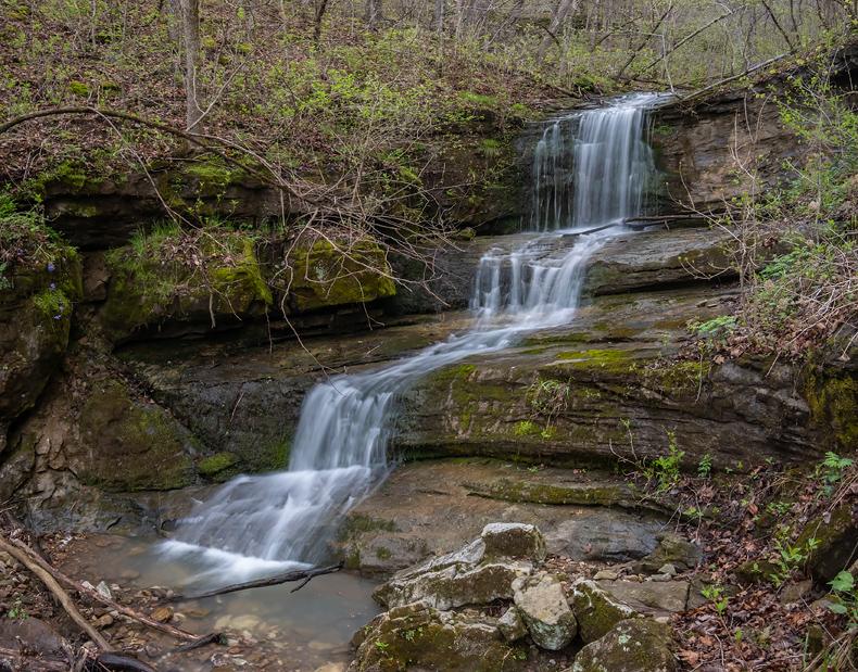
I explored a side drainage that was dry, but for some reason I decided it was worth looking at. And oh my was it WORTH looking it! Nice bluff line with a 45’ waterfall - and the entire scene was GREEN! Covered with moss, which seems like it might be a wet area all year, but for some reason the stream that normally lives there had gone underground on up the hillside. Another spot on the map to return to during high water conditions.
There was a wet waterfall further along the same bluff line, and down on the creek I came to one of the most beautiful little scenes of the trip. It was a smaller waterfall pouring into an emerald pool with mossy rocks, trees, and a giant tree root - lots of GREEN!
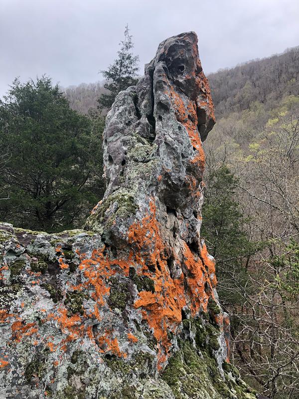
Further down the stream and up another side drainage - another beautiful waterfall in a big-boulder grotto. This one would be nicer with more water as well, but I got a good photo anyway. Near that falls I found a chunk of lichen-covered stone jutting into the sky -
So I had passed through my upper spot I had marked on the map as being suitable or waterfalls, and I had not found the waterfall that had been posted on social media, so I kept going. The creek and bluffs were pretty nice on down for a while, but only a couple of smaller waterfalls. One side canyon had several slick-rock waterfalls leading up to a larger one - in fact a really nice falls - again would be better with more water, but I like it anyway. One note about waterfalls at low flow - it doesn’t take all that much flow for a waterfall to look great in person and for you to have a great experience. But photos need more water to capture the structure and personality of most waterfalls (though too much water is not good!).
The creek twisted back and forth and I found myself in knee-deep in LEAVES - for some reason the wind pattern there kept a deep pile of leaves - even now after them having fallen nearly five weeks ago! The next side drainage was mostly dry and no waterfall, and since I had also gone through the lower spot I had marked on the maps and good for waterfalls, I was about ready to give up on finding the social media waterfall.
And then there it was! The next side drainage downstream had a small waterfall, another one above it, and THEN a quite beautiful waterfall above in a gorgeous setting - YIPPIE COYOTE! I spent a little bit of time taking pictures from different locations, and verified it was the falls I’d seen online. Once I was happy with a photo, I started to pack up and figure out the best way back UP to the van, which was now going to be a 1,200’ climb!

I decided the best and least painful route would be to simply head straight uphill from the waterfall back to the highway at the very top, then I could follow a horse trail back to my van. On my way up I veered over and realized there were several other waterfalls above the main falls - a great side trip - so seven waterfalls in this one spot.
The hike UP the steep hillside was not too difficult, especially since I had not brought any lunch or snacks with me so my pack was basically empty (I had only planned on being gone a couple of hours, haha). Then a long hike back to the van - and my lunch. It was almost 3pm and I headed home - exploration of that other new drainage would have to wait for another day...
04/20/22 I spent another amazing day in the rugged canyon that I described above - this time trying to figure out a good way for normal people to access the many waterfalls 1,200' descent, then a very steep hike back out, unless the river is low, then not so bad). I only took one photo - 'tis the same waterfall that I shot last on my previous trip (above). They kind of look the same yet are also different.

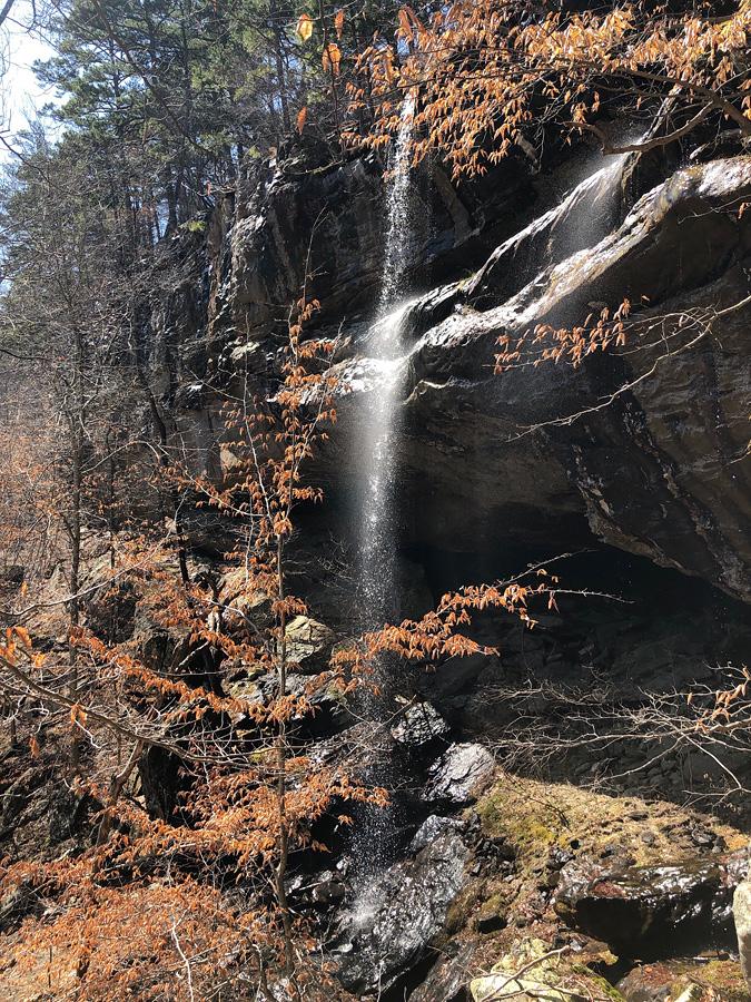
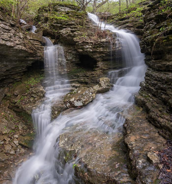
Chimney Rock Falls
04/22/22 HAPPY EARTH DAY!
04/25/22 I headed out at 5 this morning and was in the woods all day working - the falls below (top photo) is just the lower section of a 150' tall waterfall/cascade that was first on my list to photograph. Seven grueling miles of bushwhacking later I was back at the same falls shooting - looking out from the spot (bottom photo). It was another 500' elevation gain crawl back up the extremely steep hillside to the van.
Journal Archives - previous months
June 2016 Journal • May 2016 Journal Part B • May 2016 Journal Part A • April 2016 Journal
March 2016 Journal • February 2016 Journal • January 2016 Journal • December 2015 Journal • November 2015 Journal
October 2015 Journal • September 2015 Journal • August 2015 Journal B • August 2015 Journal A
July 2015 Journal • June 2015 Journal • May 2015 Journal • April 2015 Journal • March 2015 Journal
February 2015 Journal • January 2015 Journal • December 2014 Journal • November 2014 Journal
October 2014 Journal • September 2014Journal • August 2014 Journal • July 2014 Journal Part B
July 2014 Journal Part A • June 2014 Journal Part B • June 2014 Journal Part A • May 2014 Journal
April 2014 Journal • March 2043 Journal Part B • March 2043 Journal Part A • February 2014 Journal
January 2014 Journal • December 2013 Journal • November 2013 Journal • October 2013 Journal
September 2013 Journal • August 2013 Journal • July 2013 Journal • June 2013 Journal B • June 2013 Journal A
May 2013 Journal B • May 2013 Journal A • April 2013 Journal • March 2013 Journal
February 2013 Journal • January 2013 Journal B • January 2013 Journal A • December 2012 Journal • November 2012 Journal
October 2012 Journal B • October 2012 Journal A • September 2012 Journal B • September 2012 Journal A
August 2012 Journal • July 2012 Journal • June 2012 Journal
May 2012 Journal B • May 2012 Journal A • April 2012 Journal B • April 2012 Journal A
March 2012 Journal B • March 2012 Journal A • February 2012 Journal • January 2012 Journal B • January 2012 Journal A
December 2011 Journal • November 2011 Journal • October 2011 Journal • September 2011 Journal • August 2011 Journal
July 2011 Journal • June 2011 Journal
September 1998 Journal • August 1998 Journal • July 1998 Journal • June 1998 Journal • May 1998 Journal
Older Journal Archives
